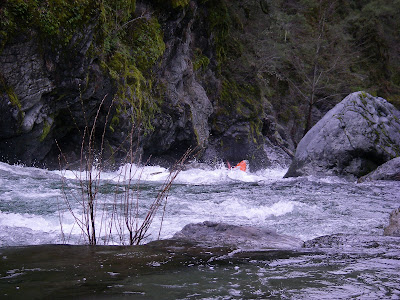
Getting buried in the Upper SF Gorge
This run is typically referred to as the best run in the Smith drainage, and with good reason. The gorge itself is fairly short, but still has more rapids than the the other main gorges. It may even have more good class IV rapids than the North Fork. Considering how rarely I hear of people running this section, I was amazed to see how large the flow window was. I would estimate our flow to be 1300 to cfs at the put-in and the gauge read 5800 at Crescent City. I thought it was a pretty reasonable first-time flow but wouldn't want to go much higher. I think lower flows would be fine on this gorge.

Peter on the hike in
The run starts with a one-mile hike in that is all downhill and goes by quickly. Once on the water, we had about a half-mile of class II/III boogey water with a couple good class IV drops we boat-scouted. Then we arrived at The Island.

Peter paddling hard somewhere on the Upper South Fork
The Island is a long class V boulder garden with two channels. Most of the water goes left over some tall ledges separated by pools. The right channel is more continuous but appears easier. Either way you go, the best way to scout is to pull over on the island itself and choose your channel and your route. After the channels converge, the river drops over a 12-foot junky ledge with lots of options. The cleanest routes are all on the left.

The junky ledge below the Island
Below The Island are a couple class IV rapids that were fairly easy down the left, followed by sharp 5-foot ledge with a fantastic boof over a meaty hole. The boulder-gardens continue for a few rapids leading up to the last big one. This last rapid is a powerful channel down the undercut left wall with a series of big holes to punch. In the spring of '08, there was a log on the bottom left, but was easy to avoid.

Below this last rapid is the three-mile paddle-out that moves along pretty swiftly through occasional class II and III rapids. Wood was more of an issue down here than in the gorge, so keep your head up.

Peter at the exit of the gorge
Access:
To reach the take-out, turn off Hwy. 199 on to the South Fork Road. Follow the road about 12 miles until you reach the fourth bridge over the South Fork called the Stevens Memorial Bridge. Be careful with maps because the gazeteer omits two road bridges near Rock Creek. Drop a bike or shuttle car at the turn-out at the upstream end of Stevens Bridge. This is also the put-in for the main South Fork run, which sucks by the way.

Peter scrambling down to the river.
To reach the put-in, continue up the road and turn right after 1/2 mile, crossing the next bridge. There should be a sign saying no winter travel and indicating mileages to Kelsey Creek, Red Mountain, and Orleans. After about 2.5 miles of climbing on pavement, turn left onto road 15N39. Follow it down to the Kelsey Creek Trailhead. From the trailhead, hike about a mile downhill until the trail forks at a switchback. Follow the upstream trail and start looking for a good spot to descend to the river. Watch out for poison oak and poor footing.
 Getting buried in the Upper SF Gorge
 Peter on the hike in
 Peter paddling hard somewhere on the Upper South Fork
 The junky ledge below the Island
 Peter at the exit of the gorge
 Peter scrambling down to the river.

Comments
Can you portage the big drops?
I'm looking to run it from the Kelsey trail put in to Goose Creek in late June in IKs, and would like to be able to scramble around anything that looks too burly...
Any helpful advice or notes would be much appreciated!
Most rapids are fairly junky boulder gardens that clean up with a lot of water. At low water, expect to portage almost every class IV because it'll all be seived out. And bring good shoes.
Also, be very wary of wood on the class II paddle-out.